
The Ripon Perambulation of 1481: a window onto the late medieval landscape of the Lower Ure Valley
By Martin Hammond
Before maps became widely available from the late 17th century on, people relied on detailed written descriptions to document important boundaries. As features in the landscape change over time, these records had to be updated periodically and this often became a ceremonial event known as a perambulation or ‘beating of the bounds’, requiring the presence of clerks and witnesses.
One such event was the Perambulation of the boundaries of the Liberty of Ripon, with a surviving transcript from 1481 providing a vivid picture of the local landscape in late medieval times. The record, in Latin, is prefaced as a:
Description of the periphery and limits of the Liberty and Lordship of Ripon, in terms of boundaries, banks and divisions, crosses, stones, rivers, watercourses, streams and cascades, stream beds and flows of waters, hills and summits of mountains, valleys, roadways, footpaths and ditches, of old positioned and assigned for the same boundary and from the time of the noble princes Oswig (father) and Alfred (son), kings of the Northumbrians, and of the most holy confessor and bishop Wilfrid the Great, Archbishop of York, recognised and accepted up to the present.
The event took place in Whit week and involved “twelve choir priests of the Collegiate Church of Ripon, wearing choral garments and bearing with them sacred relics”, along with twenty-four “honest, free and legal men living within the franchises of Ripon.” Others joined the party for part of the route.
The procession began at Brampton Thorn on the north bank of the River Ure, on the boundary between the townships of Brampton and Mulwith. It headed upstream and across the river, through woodland then along a baulk (grassy ridge) dividing the arable fields of Roecliffe from those of Westwick. Landmark trees were useful features to record, so it was noted that two crab apples grew on the baulk. Passing by another wood (no longer present) called Le Call Raynes, the boundary followed ditches as far as the Holbeck “and to a great stone on its bank commonly called St Wilfird’s Stone”. From there, the route followed the beck between meadows belonging to Bishop Monkton on one side and Burton Leonard on the other, then between Burton Leonard Moor and Monkton Field.
Here we have the three main types of agricultural land which characterised the lowland rural landscape for a thousand years. Meadows provided the hay which was essential to feed livestock and beasts of burden over the winter months, and transport horses throughout the year. These were usually on a floodplain, where flood-borne silt replenished the fertility of the soil, and were the most valuable type of land. The meadows (or Ings) were divided into numerous parcels held by individual tenants but open to common-right grazing after the hay was cut.


Clifton Ings on the River Ouse near York: a surviving example of floodplain meadow
Each township would have one or more moors (the term applied equally to lowlands and uplands; ‘common’ or ‘pasture’ place names refer to the same thing). These were large parcels of common grazing land, sometimes shared between neighbouring villages, also providing products such as gorse (for firing ovens) and bracken (for fertiliser or bedding). Not long after the Perambulation, piecemeal enclosure by landlords began to eat away at the great tracts of lowland moor, often with little compensation for the commoners: the villagers of East Tanfield were evicted and their common enclosed around 1513, for example. Nonetheless, around 12,000 acres of moor remained in the lower Ure and Swale valleys at the start of the Parliamentary enclosure era in the late 18th century.
The arable fields were open expanses divided into numerous individual strips but farmed under communal arrangements. Pre-enclosure open field names often survive to this day. All of these land uses were rigorously policed by Manorial courts to prevent mis-use and over-exploitation.

Excerpt from a manorial ‘roll’ recording court proceedings
From Burton Leonard, the bounds of the Liberty traced a sunken lane (holloway) as far as the road between Ripon and Knaresborough. After this, the route followed specified ditches, streams, baulks and lanes towards Markington, along the boundaries of Fountains Abbey’s estates and into Nidderdale.
After what must have been an arduous, multi-day trek across Nidderdale then descending the Laver valley, the procession re-entered the Ure valley via Monkstone Wall Yate, a gate on the road from (Old) Sleningford to Azerley. Passing Sleningforth Ings (now at Mickley), the boundary followed the middle of the Ure downstream to “a certain place called Holt Bank” and an area called the Flaske. Flaske refers to marshy ground, the same applying to Flasks Lane at Nosterfield and Bell Flask near Wath. Thence it passed along an old course of the river: the natural migration of wild rivers was one reason boundaries needed to be re-iterated and explains the seemingly mysterious route of some Parish boundaries on modern maps.
The procession passed Reed Bank in North Stainley Pasture to Penny Croft, part of the Archbishop of York’s estate at Ripon Parks (this is where the new Hanson Aggregates quarry is located). Skirting Penny Croft along the mid-line of the Ure, the procession reached “a certain plaster quarry called Sparre Stone”, where gypsum would have been dug. Following a convoluted path crossing the river back and forth, floodplain meadows called Sparre Stone Ing and Nunwick Longing are mentioned. The boundary then tracked uphill by the open fields of Norton, Wath and Nunwick then Melmerby Moor.
Returning to the Ure, the Perambulation passed through more meadows at Conyers Ing and Sunning, the latter being the meadow land of Sharow and later an early site of Ripon Racecourse. The numerous Ings illustrate how important hay production was in the floodplains: in fact, around 100 such historic meadow sites have been identified in the lower Swale and Ure valleys but almost none of this habitat survives – Bishop Monkton Ings is an exception but is now fen and wet grassland rather than hay meadow.
The boundary of the Liberty hereabouts was particularly convoluted (“often straight then veering” is one phrase) but landmarks included four ancient stones and a place called Turff-carr Rayne: this was a wetland where peat or fibrous turf would have been dug for fuel. Woodland was present at Scroggisceughe Wood (since lost) and Theidale (on the border between Hutton Conyers and Copt Hewick). Grazing commons in the form of Moors or Pastures are identified at Copt Hewick, South Hewick, Marton-le-Moor and Skelton-on-Ure. Ditches or small streams often demarcated Moors from (arable) Fields.
Finally, wetlands (carrs) are mentioned in the form of Brankcarr, Cock Carr, Moys Marsh, Dampkarr and Bramp Carr and Swincarr. Around 150 wetlands, large and small, have been identified in the pre-Enclosure landscape of the lower Ure and Swale valleys and almost every township had one or more.
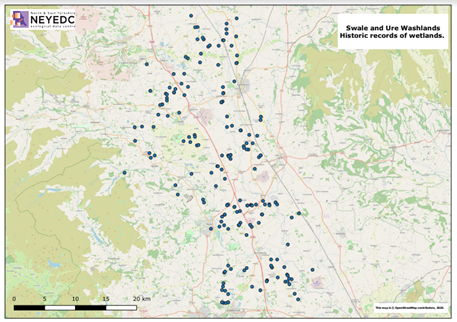
Historic wetlands in the lower Ure and Swale Valleys of North Yorkshire

The Sunings was the site of Ripon Racecourse when the first edition Ordnance Survey 6” map was published in 1856 but in 1481 it was one of several riverside Ings (hay meadows) through which the Perambulation passed.